Does not look good for the Houston/Galveston area. I’ve rejected inspections for Friday to prepare for the storm. Gonna be a big one.
Hang in there Texas! :shock:
John…do me a favor & run down to my boat in Kemah & make sure it’s snugged up real good. Thanks.
Wouldn’t you rather I run it out and anchor it in the bay? :neutral:
You may be on to something…the insurance is all paid up. Stand by…let me think 
Good Luck to all of you. Stay Safe!!!
You took the words out of my mouth Greg
Good luck to all on the Texas & Louisiana coasts
Regards
Gerry
If you guys need a place to stay, contact me. I am north of Houston near Crockett TX.
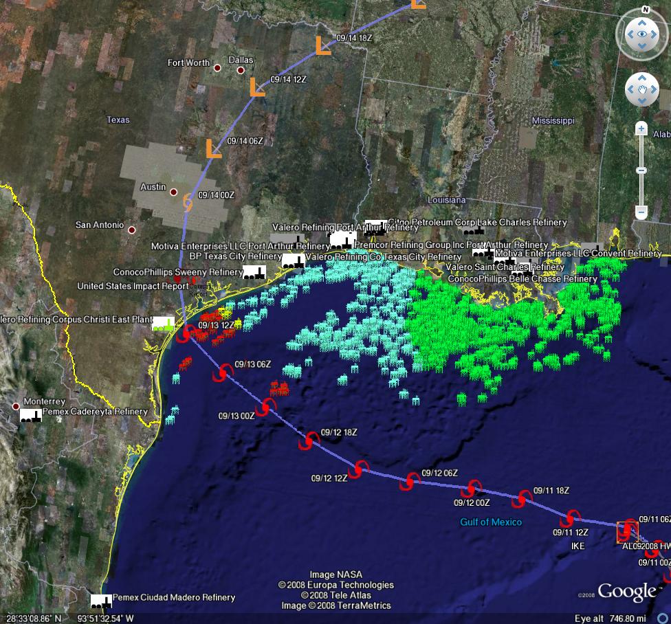
Hurricane Ike’s current track predicts landfall between Corpus Christi and Galveston Saturday morning; but the storm isn’t strengthening much yet and the track has been moving northwards–so, because of the wobbles in the track, models are still uncertain. Within the current NHC storm path lies about 5 million bpd of US petroleum refining capacity. (Perspective: 5 MMBBL is about 30% of US capacity (about 15 MMBBL), and a bit less than 6% of global capacity (~85 MMBBL). Also, the MMS reported Wednesday that staff has been evacuated from 452 production platforms (63.0%) and 81 rigs (66.9%) – (95.9% of the oil production and 73.1% of the natural gas production has been shut-in as a precautionary measure for Hurricane Ike.)
Because of that uncertainty, Chuck asked us to present two scenarios from respected models at this time. One is relatively innocuous, the other, well, not so much. Updated 9/11 9:30 EDT.
http://hurricane.methaz.org/tracking/data/al092008_ofcl_windcats_map.png
http://www.theoildrum.com/files/hwrf_thu.jpg
Current path estimates for Hurricane Ike (Methaz HWRF Sep 11 (9a EDT)-click twice to enlarge
http://www.theoildrum.com/files/gfdl_thu.jpg
Current path estimates for Hurricane Ike (Methaz GFDL Sep 11 (9a EDT)-click twice to enlarge
For all graphics: Rigs/Platforms: Blue: evacuated only; Yellow will require inspection before restart; Red: damage requiring repair; Refineries: Black: operational impact (partial shutdown) Green: Operational impact (full shutdown) Red: Damage likely; Ports: standard hurricane flags for wind
Here is the latest update from Chuck Watson at KAC/UCF as of 11 Sep 9:30 EDT:
Ike continues to wobble towards Texas - where is still an open question - and continues to not intensify. As noted by NHC this morning, the interior structure of Ike is unusual. It’s not unusual for a storm to have two eyewalls during what is called an eye replacement cycle; it is unusual to maintain these structures over an extended period of time. The outer wind maximum is helping to keep Ike weak; if it collapses the inner core can strengthen rapidly. I’m still thinking mid Cat 3 is the max this storm will get, and high Cat 2 at landfall, but those who argue for Cat 4 could still be right if Ike gets his act together - I just don’t think that is likely. As usual, take all such speculation with a grain of salt and if you are in the way of the storm get out.
As for impacts, here are two scenarios, offered by two respected dynamical models. The first, from HWRF, goes south towards Corpus Christi. It would damage about 5% of GoM production, and damage less than 1 MMBBL/day of refinery capacity (bad, but not catastrophic). The second, GFDL (which is the best performing model for Ike, and as of the 8am position fix is closest to observed track), is rather unpleasant: 15% production impact (bad, but again not catastrophic), but we stand to lose nearly 6 MMBBL/day of refinery capacity for over a month. That’s 38% of US Capacity, and 6% of global capacity. Is catastrophic too strong a word - I don’t think so. There just isn’t that much spare capacity in the system, so I would expect shortages of refined products if the GFDL scenario plays out. But always keep in mind that small wobbles and intensity changes make a huge difference in damage. The NHC track, which splits the difference between these two tracks, give us 8% production damage and less than 2 MMBBL refinery damage. As I said yesterday, the refinery damage is what to watch in this storm. We should have a better picture this afternoon, when the storm might turn more to the north or continue towards Corpus.
Woo Hoo, hurricane keg party at John’s. I’ll bring the munchies.
Hurricane Ike’s current track predicts landfall within 100 miles of Galveston Saturday morning; but the storm isn’t strengthening much yet and the track has been moving northwards–so, because of the wobbles in the track, models are still uncertain.
Within the current NHC storm path lies about 5-6 million bpd of US petroleum refining capacity. (Perspective: 5 MMBBL is about 30% of US capacity (about 15 MMBBL), and a bit less than 6% of global capacity (~85 MMBBL). Also, the [FONT=Verdana]MMS](http://www.rigzone.com/news/article.asp?a_id=66473) reported Wednesday that staff has been evacuated from 452 production platforms (63.0%) and 81 rigs (66.9%) – (95.9% of the oil production and 73.1% of the natural gas production has been shut-in as a precautionary measure for Hurricane Ike.) Updated 9/11 15:00 EDT.[/FONT]
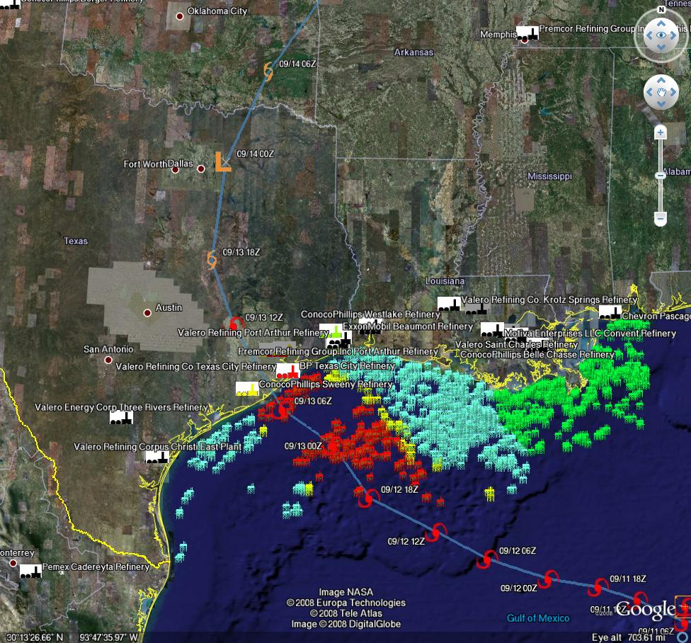
The latest track models are converging on the Houston area, between Freeport and High Island. That’s bad news from a refinery perspective. The question is increasingly shifting from “where” to “how strong”, and with Ike that’s a tough question to answer.
The threshold to watch for as the storm approaches landfall is 100 knots (115mph). For every 5 knots less than that the damage drops off rapidly, and more importantly the recovery times improve. If the storm landfall intensity is over 100 knots, we start to see damage that requires major structural work and therefore recovery times start to skyrocket.
The latest GFDL scenario is not pretty, and the refinery estimate from this morning (nearly 6 MMBBL/day of refinery capacity for over a month, (38% US/5% global capacity) is in play.
I’m still skeptical the surface winds will be over 100kts at landfall. The good news is that Ike is having a hard time getting organized. There is a fair amount of dry are to the west, and if it gets entrained the storm will collapse. The bad news is that Ike is still pushing the dry air out of the way, and there is still plenty of time for it to get organized. Lots of discussion about the size of the wind field, and it is true that will elevate water levels and damage coastal property. But from the oil/gas perspective, that doesn’t concern me as much as the organization of the winds in the core and damage swath. HWRF essentially crashes the intensity to tropical storm strength before landfall - I think that’s pretty dramatic, but a cat1 landfall wouldn’t surprise me. A Cat 3 would. Again, don’t bet your life on it - get out of the way!
Oh yeah!!! Root Beer.!
[FONT=Arial]I just got the word that my 93-year old mother is being evacuated from her nursing home in League City to San Antonio![/FONT]
[FONT=Arial]This is the 2nd evac from her! [/FONT]
[FONT=Arial]{Hurricane Rita was the 1st.} [/FONT]
Hey, John!
Be well & stay safe, friend!
Russ
Looks like this new Join Date feature is off base, as my ID # is #03060502.
Maybe that’s the join date for the MB; I was kinda quiet in the beginning . . .:roll::roll::roll:
Frank…I’m sure she will be well taken care of. God bless her and watch over her.
The wind is beginning to pick up a little on Galveston Island this morning. I’m monitoring several NOAA buoys and offshore weather stations and the Shell drilling platform ‘Auger’ is reporting 125 mph sustained winds and 26’ seas right now. I’m most concerned about the storm surge as a 15’ to 18’ surge could put considerable parts of southern Harris County under water.

Mike,
I want to thank you for your prayers. They are sorely needed.
I have two brothers who live in League City and… they both decided to “Ride It out”.
One lives on the 2nd floor of a condo complex and the other has a “Ranch” style home.
Both knuckle heads told me that after evacuating for “Rita” and coming home to find everything “high & dry” that they decided not to leave for “Ike”.
I guess that within the next 48-hours that they will have a story to tell.
Frank, here’s a satellite photo of my boat at the Kemah Boardwalk not too far from League City. A 20’ surge will be catastophic for all of the marinas. It will be interesting to see how it looks tomorrow morning.

I used to live in Northwest Houston {Near Jersey Village} and we used to make the long drive to Kemah for some of the best seafood on the Gulf Coast.
By the looks of things they will have “seafood” swimming down Main street! :shock: